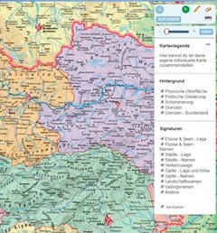
Grundwissen Österreich neu
Gesamtösterreich und alle Bundesländer basierend auf bewährten Schulwandkarten zur Vermitltung geographischen Grundwissens über Österreich

Gesamtösterreich und alle Bundesländer basierend auf bewährten Schulwandkarten zur Vermitltung geographischen Grundwissens über Österreich

Administrative Maps Germany from STIEFEL

Landkreis Rosenheim, digitale Schulwandkarte physisch mit stummer Arbeitskarte

Simple physical geographic Map about the World for easy geographical world brain training and learning with Zoomfunction and painting tools.

Contains a map with the biggest and most impressive landforms of your planet.

Shows you the most important regions in Europe and Austria

Program is only available in German language

Basics of Germany content several topics concerning the configuration and structure of Germany. Teachers and pupils can select special information and switch it on or off. The geographical knowledge is trained with playful exercises, which facilitate the rating of dimensions and the allocation of geographical terms.

Die Wandkarte: "Entwicklung der Menschheit" als digitales Bilderbuch, zum Durchblättern. Aufgrund der hohen Bildqualität auch hervorragend zur Präsentation über Beamer an Whiteboards geeignet, unterstützt Sie dieses Produkt hervorragend bei der Erarbeitung des Themas im Unterricht.

Die Viererkarte: " Nordrhein-Westfalen in Deutschland, Europa und der Welt" als übersichtliches digitales Kartenbilderbuch zum Durchblättern, Seite für Seite. Aufgrund der hohen Bildqualität hervorragend zur Präsentation über Beamer an Whiteboards geeignet, unterstützt Sie dieses Produkt effektiv bei der Erarbeitung des Themas im Unterricht.